Saturday 1200 am
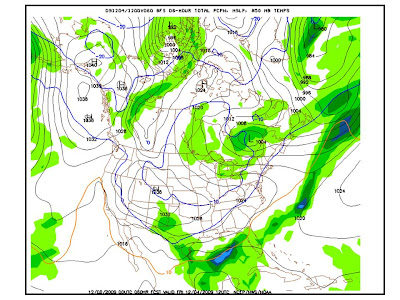
I have attached images of the latest model for this coming Friday. They start at midnight and go every six hours till Saturday at midnight. The blue line you see over Texas on the map is they call the 850mb 0 line.. Think of weather as 3D. It's not just what is happening overhead, there are many layers to the atmosphere. Some warmer, some colder.
I have attached images of the latest model for this coming Friday. They start at midnight and go every six hours till Saturday at midnight. The blue line you see over Texas on the map is they call the 850mb 0 line.. Think of weather as 3D. It's not just what is happening overhead, there are many layers to the atmosphere. Some warmer, some colder.
Each layer is measured in MB (Millibars), 850mb is 5000 feet into the atmosphere. It is usually at 850MB where it is the WARMEST above the surface and usually represents anything north of that line is snow, anything south of the line is rain/sleet/ice.
The 0 stands for 0 celcius, which is the freezing point. The second blue line, around Kansas, is -10 Celsius. For snow to happen it has to be below freezing on EVERY LAYER minus the surface, which can get snow a couple degrees above 0 Celsius. The surface is 1000mb, from about 975mb up it CANNOT be above freezing, otherwise it will NOT be snow. But 90% of the time, the warmest temp will be 850mb and that is why they represent it on that map of where that freezing mark is at 5000 feet..
The models are never PERFECT, but you can almost bet that if you are North or within that 0c line and there is moisture, it will be snow. Of course you will never know until it actually happens, but the latest models are definitely predicting snow all the way to the Gulf Coast on Friday.


No comments:
Post a Comment